Digging Deep: Update on Collaborative Energy Research – the BC Seismic Research Consortium - November 2023
By: Randy Hughes, Manager Energy & Water
This edition of the Digging Deep blog provides updates on the BC Seismic Research Consortium over the past two years and details a 12-month extension of the project.
A previous edition of Digging Deep provides further background.
Induced Seismicity Monitoring Passes 10-year Milestone
Since 2012, monitoring of induced seismicity (earthquakes caused by human activity) from energy operations in BC’s Northeast Region has been led by a consortium funded by Geoscience BC and the BC Oil & Gas Research and Innovation Society (BC OGRIS), along with consortium partners the BC Energy Regulator (BCER) and the Canadian Association of Petroleum Producers (CAPP). Natural Resources Canada (NRCan) provides in-kind technical and operational support to the consortium. The research is the outcome of a recommendation from the BCER in response to concerns regarding induced seismicity associated with hydraulic fracturing in the Horn River Basin. It has been instrumental in helping the BCER understand induced seismicity, while guiding regulatory decisions and helping natural gas operators design best practices for the mitigation of such events.
The nine-station network spans from the Horn River Basin (north of Fort Nelson) to the southern extent of the Montney Play (south of Dawson Creek). It includes the Kiskatinaw Seismic Monitoring and Mitigation Area (KSMMA) and the Ground Motion Monitoring Permit Condition Area (GMMPCA).
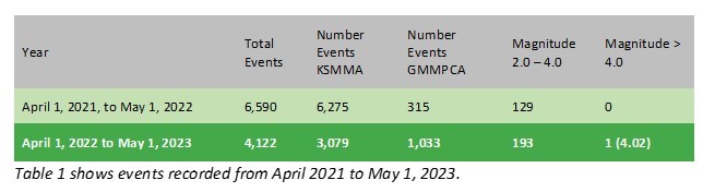
Seismic monitoring in the region is now considered to have reached a relatively stable state of operation. Few changes have therefore been made to the routine monitoring system in the last year. However, real-time earthquake monitoring has been enhanced with notifications sent to interested parties within minutes of a seismic event occurring. Events are published to the BCER seismic web map and continual improvement in autodetection of events are made using AI. An enhancement to the earthquake detection system in 2021-2022 added a feature to allow for increased location accuracy for events relative to each other, and to reveal features of interest such as the mapping of lineations.
New Funding Announced for Further Year of Monitoring
Geoscience BC and BC OGRIS have now approved a one-year extension of funding, including industry contributions, for the consortium network to allow for continued monitoring and collection of this critical seismic data, important for induced seismicity research. All raw waveform data collected is made publicly available through the Seismological Facility for the Advancement of Geoscience (SAGE) operated by the EarthScope Consortium (formerly known as the Data Management Center of the Incorporated Research Institutions for Seismology, IRIS DMC), and the consortium generates an annual seismicity report. The Consortium’s Steering Committee and Technical Advisory Committee have worked together to continue the network operation and maintenance program, the ongoing analysis of raw waveform data, and recommendations to install new stations where needed.
Sustainable Funding Model Required
The funding extension continues the BC Seismic Research Consortium to September 2024. Partners are seeking long-term funding for the project to ensure continued monitoring and accessible public data about induced seismicity in BC’s Northeast Region. This is essential to understanding and regulating induced seismicity and to mitigating risk.

If your organization is interested in contributing, please contact us at info@geosciencebc.com
Geoscience BC gratefully acknowledges the financial support of our partners, including the Province of British Columbia through the Ministry of Energy, Mines and Low Carbon Innovation.
Bibliography
- Salas, C.J., Walker, D. and Kao, H. (2013): Creating a Regional Seismograph Network in Northeast British Columbia to Study the Effect of Induced Seismicity from Unconventional Gas Completions (NTS 094C, G, I, O, P); in Geoscience BC Summary of Activities 2012, Geoscience BC, Report 2013-1, p. 131–134.
- Salas, C.J. and Walker, D. (2014): Update on Regional Seismograph Network in Northeastern British Columbia (NTS 094C, G, I,O, P); in Geoscience BC Summary of Activities 2013, Geoscience BC, Report 2014-1, p. 123–126.
- Babaie Mahani, A., Kao, H., Walker, D., Johnson, J. and Salas, C. (2016): Regional Monitoring of Induced Seismicity in Northeastern British Columbia; in Geoscience BC Summary of Activities 2015, Geoscience BC, Report 2016-1, p. 79–88.