Summary
The Bowser Basin underlies approximately 50,000 km2 of north-central British Columbia and is considered a frontier hydrocarbon basin. Bowser Basin strata of the Middle Jurassic to mid-Cretaceous Bowser Lake Group overlie volcanic and clastic rocks of the Early to early Middle Jurassic Upper Hazelton Group (Spatsizi Formation). Bowser strata were deposited in a wide range of clastic sedimentary environments, from deep distal marine through slope, shelf, deltaic, fluvial, and lacustrine. 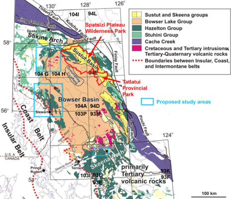 They contain minor carbonates which could potentially be source rocks, and a huge volume of dark grey mudstone, siltstone and shale which are potential source rocks. In addition, fine grained sediments of the Spatsizi formation contain elevated total organic carbon (TOC) and are excellent potential source rocks. The Bowser lake group was deformed by folds and thrust faults to result in the Skeena Fold Belt.
This project will involve field and laboratory investigations by the principle proponent and a graduate student. Fieldwork will investigate selected, stratigraphically intact successions through the basal parts of the Bowser succession. Follow-up laboratory work will include petrographic and geochemical investigations of samples from sedimentary successions. Macrofossils will be collected to refine the stratigraphy, and microfossils, particularly Radiolaria, will be dated with the assistance of appropriate specialists. In addition, to further constrain the subsidence rate of the basin, a program of U-Pb dating of volcaniclastic zircons will be undertaken with the assistance of the staff of the Radiogenic Isotope Facility at the University of Alberta.
The project will aim at preparing sedimentation-rate curves for the basin fill, appropriate to several regions within the basin, which will then be combined with water-depth estimates to produce subsidence curves for the basin. This effort will be facilitated by the good paleontological control and rapid sedimentation rates already documented for the basin. In addition, large portions of the basin fill were deposited in shallow marine or coastal/deltaic environments, allowing us to obtain good constraints on water depth. These curves will help to distinguish between competing models for the origin of the basin (foreland basin, strike-slip basin, rift basin) which have important consequences for petroleum prospectivity.