Summary

The goal of this project was to help assess the hydrocarbon and mineral potential of the Nechako Basin in the Interior Plateau region of south-central BC. This will be accomplished by mapping the structure of the Nechako Basin using passive source seismology. Specifically, waveforms from distant earthquakes will be used to resolve the shear-wave velocity structure beneath the basin and provide information on the thickness and nature of the basin-fill sedimentary rocks and also on the thickness of the underlying crust.
The combination of P- and S-wave velocity information provides constraints on Poisson's ratio, which is indicative of lithologic composition. By integrating S-velocity information with gravity and MT data, results can be verified and constraints on pore-fill fluids and fracture characteristics can be estimated. This information can be used to develop and constrain models of basin architecture, identify pathways for fluid migration and provide insight into basin composition, all of which are required to further our understanding of the basin's resource potential.
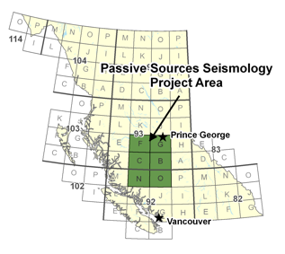
This project represents a unique, and very cost-effective means to provide regional-scale structural information (at seven sites situated over an area of approximately 33,000 km2) that will help direct future targeted studies (including MT, active source seismic, and drilling) by industry and other groups. A key component of this project will be training a graduate student in multidisciplinary geophysical research.

The advantages of this method are numerous:
- using natural earthquake sources means that permitting/explosions are unnecessary;
- the energy is "coming from below", enabling us to see "below the basalts" that blanket the underlying prospective units and have degraded the quality of active source seismic data; and
- the S-wave information obtained complements the P-wave information obtained from active source seismic studies.