Summary
The Nechako Basin, which is located in the interior plateau of British Columbia between the Coast Mountains and the Rocky Mountains, has seen almost no exploration for hydrocarbons, in marked contrast to the western Canadian sedimentary basin. The structure and hydrocarbon potential of the basin is poorly understood, but its proximity to existing infrastructure implies that any discoveries can be tied in at relatively low cost. In this project, 25-year old seismic data which was acquired in the southern part of the Nechako basin by Canadian Hunter, will be correlated with existing well logs, and interpreted in collaboration with the geologists of the BC Ministry of Energy, Mines and Petroleum Resources. 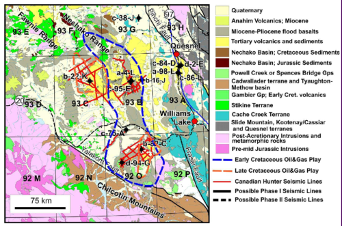
In particular, we will map the variations in thickness and structural style of the Early Cretaceous Skeena- Jackass Mountain sediments that have to date hosted all the oil shows detected by wells drilled into the basin. Based on the hypothesised thickness of these sediments, it has been suggested that they host up to 8.7 TCF of gas and 4.9 billion barrels of oil. We will also correlate the quality of these seismic data with the known surface geology, and volcanic cover in particular, to constrain its influence on the quality of any future seismic data acquisition. The involvement of significant thicknesses of Early Cretaceous sediments in compressional folds or fault blocks, which are the traps characteristic of this environment, will likely spur renewed industry interest in the basin.
Image: Geology of the southern Nechako basin with NTS map numbers showing locations of existing seismic lines. The outline of the major region of the Early Cretaceous Skeena-Jackass oil and gas play, which is considered to have the greatest hydrocarbon potential in the basin, is shown by the dashed blue line (modified from map supplied by F. Ferri, RDBC).