Summary
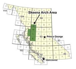
 The Skeena Arch transects central British Columbia and represents a long lived magmatic arc that has produced a diverse range of mineral deposits in a wide variety of geologic settings. It is some of the most richly endowed terrain in British Columbia and has been the site of mineral exploration since the turn of the century. Since 1985 the BC Geological Survey Branch and the Geological Survey of Canada have been involved in regional mapping projects along the Skeena Arch, first as part of the Whitesail and Smithers projects and more recently as part of the Interior Plateau and Nechako NATMAP projects. This work has resulted in a much better understanding of the geologic evolution of the arch, particularly during the metallogenically important Jurassic through Cretaceous time periods. Although there are gaps in the map coverage, a large part of the proposed project area has now been mapped in detail.
 A key objective of the Skeena Arch project was to generate a series of GIS compatible data files that could be downloaded and incorporated into standard GIS software packages. The files are available as ESRI shape files as this format can be used in almost all commercially available GIS packages including ESRI's free Arc Explorer. Two projections are currently available -- UTM and Geographic. Also included for download is a Manifold GIS Map file that contains all of the layers used to build the Skeena Arch metallogenic map. Manifold also supports the creation of KLM files for use in viewers such as Google Earth. The following KML layers were generated for the project area: RGS, copper and molybdenum anomalies; MINFILE and Porphyry Cu-Mo and Mo occurrences; geology layers, including Babine, Bulkley and Nanika intrusive suites, faults and marker units; and logging roads.