Digging Deep: Collaborative Water Research - October 2022
By: Randy Hughes BSc, Manager Energy & Water
Water Data to Inform Decisions
To better inform decision-making on water use in British Columbia’s Northeast Region, additional data is needed regarding water quality and quantity. This is being addressed by the Pilot Collaborative Water Monitoring Program, NortheastBritishColumbia program.
Three integrated studies use climate, surface and groundwater monitoring stations at sites in the Peace region. Baseline data is being assessed for watershed water balances, surface water flows and groundwater-surface water interactions. Most Treaty 8 First Nations are participating in the study to gather Indigenous knowledge from several sites.
Findings from this pilot program can inform future research to aid resource development that considers economic, environmental and Indigenous values and rights.
The studies are:
- Northeast BC Hydrometric Monitoring Network Improvements (2019-016);
- Traditional Knowledge and Scientific Data Education, Comparison and Collaboration in Northeast BC Surface Water Use (2019-018);
- Coordinated Groundwater, Surface Water and Climate Monitoring Program, Northeast BC (2019-023).
Advancing Baseline Water Knowledge
Geoscience BC has supported research into water resources in BC’s Northeast Region for over a decade, with examples such as:
- Horn River Basin Aquifer Mapping and Characterization;
- Northeast Water Strategy (NEWS) Hydrometric Monitoring Program; and
- Peace, a program to share new baseline information about groundwater resources.
The multi-year, multi-partner Pilot Collaborative Water Monitoring Program, Northeast British Columbia addresses a recommendation in the BC Ministry of Energy, Mines and Low Carbon Innovation’s 2019 Scientific Review of Hydraulic Fracturing in British Columbia report to increase water quantity and quality monitoring in BC’s Northeast Region. The three projects in the program are led by researchers from the BC Oil and Gas Commission, Matrix Solutions Inc., the Ministry of Energy, Mines and Low Carbon Innovation and Shell Canada Ltd. To date, most Treaty 8 First Nations are participating in the study.
As a pilot program, the studies aim to identify and overcome monitoring challenges and inform future monitoring activities. Solutions have included co-locating different types of monitoring equipment at selected sites, and coordinating with First Nations on data collection.
Co-Located Monitoring Sites and Indigenous Collaboration
Five sites are undergoing full or partial monitoring depending on site suitability. The objectives of the monitoring are hydrometric (water depth, temperature and stream discharge); water quality (chemistry); benthic sampling under the Canadian Aquatic Biomonitoring Network program; climate; and groundwater monitoring and aquifer presence. Groundwater is monitored via newly drilled wells that collect soil/bedrock information and monitor water levels and chemistry via sampling. Treaty 8 First Nations members have been, and continue to be, trained on data collection, sampling and station maintenance across the sites.
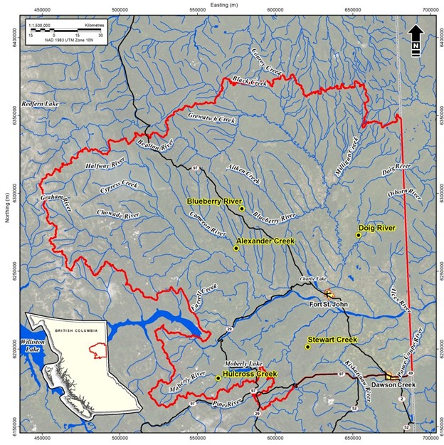
Five sites across the Peace region were selected for co-location of monitoring stations.
Installation of monitoring stations and subsequent data collection began in 2021 and have continued into 2022. As challenges with Covid-19, wildfire, flooding and global supply chain issues have led to a delay in program rollout, Geoscience BC has extended the program until December 2023 to allow for monitoring during summer 2023, data analysis and final report development. All data collected will be shared publicly through Geoscience BC and the provincial Aquarius and Water Portal sites.
A crucial component of the program is the gathering of Indigenous knowledge (traditional and contemporary) to integrate it with western science and to better understanding community concerns relating to water levels in the region. This collaborative learning process is ongoing. The research team has made progress engaging Treaty 8 First Nations in gathering Indigenous knowledge and recognizes the benefit of this longer-term endeavour that respects the relationship-building process and protocols in place for such collaboration.
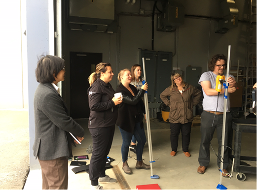
Members of local First Nations have been trained on equipment maintenance, water sampling and data gathering.
Conclusion
With ground and surface water resource management of key importance to Indigenous groups and all communities across the province as they seek data-backed solutions to mitigate climate change impacts, initiatives such as this pilot program are essential for the longer-term. Lessons learned and the integration of Indigenous knowledge and western science, in a two-eyed seeing approach, this program creates the foundation for additional monitoring programs moving forward.
Program activities to the end of 2021 are reported in Geoscience BC’s 2021 Summary of Activities Energy and Water volume. Further reports will be released in due course as the program progresses.

Is this research valuable to your organization or community?
Geoscience BC membership opportunities make it easy for a wide range of partners to support, provide input, network and stay up to date on Geoscience BC minerals, energy and water research. Join today!