string(10) "[Minerals]"

Golden Triangle Geophysics Data Compilation Project

Lead Researcher(s):  

Project ID:  2018-056

Key Research Organization(s):  Geoscience BC

Project Location:  Northwest BC

Strategic Focus Area:  Minerals

Summary


This project added to publicly accessible geophysical data in an area known as the Golden Triangle in British Columbia’s Northwest Region by acquiring and publishing industry data that was previously private. Existing public data sources have also been listed to create a comprehensive compilation for Golden Triangle geophysical data. The Golden Triangle is BC’s most active mineral exploration and development area and hosts several operating and past-producing mines.

The Need

Regional geophysical data is used to help understand a region’s geology. Magnetic data is used to identify changes in geology that can highlight potential mineral exploration targets. Magnetic data can be used to generate two-dimensional maps and three-dimensional models to identify potential mineral deposits.

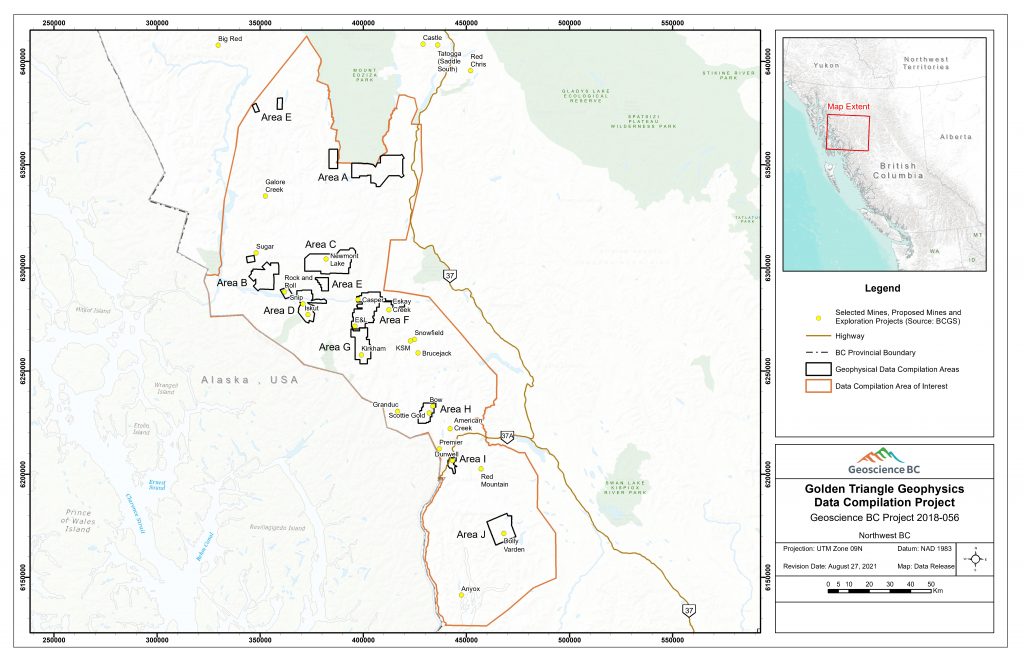
This project focused on acquiring, reviewing and purchasing existing airborne magnetic data for the Golden Triangle that was not publicly available. Links to other existing public geophysical data in the region are also provided.

Bringing together high-quality data for the Golden Triangle region has short- and long-term uses, including improving the understanding of the area’s major geological features and the mineral systems throughout the region.

Project Goals

This project fits under Geoscience BC’s Strategic Objective of ‘Identifying New Natural Resource Opportunities’ and the goal to:

  • Undertake research that adds value to existing or ongoing data sets through ground-truthing studies, data interpretation and mining camp compilations.

Specifically, this project:

  • Published previously private airborne geophysical data sets in the Golden Triangle area; and
  • Highlights existing public geoscience data in the Golden Triangle.

Project Benefits

Publishing detailed geophysical data can enhance interpretation of the geology and mineral potential in the Golden Triangle by mineral exploration companies, Indigenous groups, governments and academia.

Data from this project may also be used to guide future public geoscience initiatives.

Location Details

The Golden Triangle is in the Regional District of Kitimat-Stikine in BC’s Northwest Region. An outline of Geoscience BC’s area of interest can be seen on the map below. This area was selected based on an evaluation of existing public geoscience data and input from Indigenous groups in the area.

The northern boundary of the area of interest is directly south of Geoscience BC’s previous QUEST-Northwest project, which included geological mapping, geochemical sampling and geophysical data collection around the communities of Dease Lake, Iskut and Telegraph Creek.

Areas where Geoscience BC acquired data are shown on the map in the deliverables section.

View PDF Map of Project Area

View QUEST-Northwest Project

Deliverables


  • Final Deliverables

    To provide the most comprehensive set of publicly available airborne magnetic geophysics for the Golden Triangle the following deliverables have been compiled.  This includes newly public data for 26 surveys blocks provided by 10 companies, links to 9 ARIS reports with the original data available from the Ministry of Energy, Mines and Petroleum Resources and a link to Natural Resources Canada’s Geoscience Data Repository for Geophysical Data.

    Newly produced reduced to pole, reduced to pole first vertical derivative and reduced to pole total gradient amplitude layers from each of the 26 new survey blocks can be viewed in the Earth Science Viewer by clicking the Golden Triangle Geophysics Compilation layers under the heading Minerals Data -> Geophysical Data -> Golden Triangle Geophysics Compilation: LINK

    • Geoscience BC Report 2021-15: Golden Triangle Geophysics Data Compilation Project Summary (PDF, 404 KB)
    • Areas A-J: All of the purchased data compiled into a single file which include 26 magnetic survey blocks, 19 electromagnetic survey blocks and 6 spectrometer survey blocks in Areas A to J (ZIP, 8.4 GB)
    • Area A: Magnetic geophysical surveys for 3 survey blocks and magnetic and spectrometer surveys for 1 survey block. Includes original data, original reports and new data. (ZIP, 1.5 GB)
    • Area B: Magnetic and Versatile Time Domain Electromagnetic geophysical surveys for 5 survey blocks. Includes original data, original reports and new data. (ZIP, 1.1 GB)
    • Area C: Magnetic and Electromagnetic geophysical surveys for 3 survey blocks. Includes original data, original reports and new data. (ZIP, 425 MB)
    • Area D: Magnetic, Electromagnetic and Spectrometer geophysical surveys for 1 survey block. Includes original data, original reports and new data. (ZIP, 999 MB)
    • Area E: Magnetic and spectrometer geophysical surveys for 3 survey blocks. Includes original data, original reports and new data. (ZIP, 1.8 GB)
    • Area F: Magnetic geophysical surveys for 2 survey blocks. Includes original data, original reports and new data. (ZIP, 245 MB)
    • Area G: Magnetic and Versatile Time Domain Electromagnetic geophysical surveys for 4 survey blocks. Includes original data, original reports and new data. (ZIP, 450 MB)
    • Area H: Magnetic and Electromagnetic surveys for 1 survey block. Includes original data, original reports and new data. (ZIP, 1.6 GB)
    • Area I: Magnetic geophysical survey for 1 survey block. Includes original data, original reports and new data. (ZIP, 109 MB)
    • Area J: Magnetic and Electromagnetic geophysical surveys for 1 survey block. Includes original data, original reports and new data. (ZIP, 171 MB)
    • GBCR 2021-15 README File for Data Deliverables: Basic descriptions of the data for each area. (PDF, 109 KB)
    • 2021-15 Geophysical Data Available from ARIS: A linked table that provides the location and some basic metadata for assessment reports that are publicly available with the original geophysical data. (XLS, 11 KB)
    • Natural Resources Canada Geoscience Repository for Geophysical Data: This link provides access to Natural Resources Canada’s repository for geophysical data which provides a variety of geophysical survey from across Canada.


    Geoscience BC encourages anyone considering staking a mineral claim or conducting any type of mineral exploration work to engage early and engage often with appropriate local Indigenous groups. The Association for Mineral Exploration (AME) provides an Early Engagement Planning Tool. The Province of British Columbia’s Consultative Areas Database can be used to identify potentially impacted First Nations and their respective contacts.

  • Technical Articles

Feedback
How Useful Has The Data You've Used From Geoscience BC Been? Please Rate From 1 - 5
1 (Poor)
5 (Excellent)
Which of the following best describe your role and how you use Geoscience BC research
Do you have any additional comments?
Send
Did you know Geoscience BC sends out regular research updates?
Thank you for submitting your feedback!