Summary
 The QUEST geophysical survey region contains about 650 MINFILE occurrences and 2,484 ARIS Assessment Reports. MINFILE occurrence descriptions in the QUEST area are several years out of date - last updates range from 1989 to 1996. Staking activity resulted in increased Assessment Reports that will enhance or add new mineral occurrences.
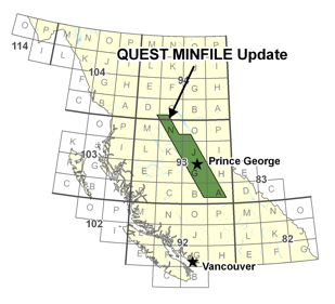
 The QUEST geophysical survey region covers the core of the Quesnel Belt. The following map sheets, in terms of MINFILE, have 522 occurrences and about 80% of the total [descending order]: 093A, 093N, 093H, 094C, 093B. These top-five map sheets also represent where the bulk of recent exploration has occurred. The following mapsheets have the greatest number of ARIS reports [descending order]: 093A, 093N, 093B, 093H, 093G. This represents 2014 reports and 80% of the total in the geophysical survey area. MINFILE occurrences will be updated based on review of Assessment Reports, Property File, news releases, formal publications, recent exploration and the web.