Summary
The Nechako Basin in central British Columbia is considered an area prospective for oil and gas resources. The Skeena group, comprising several thousands of meters of Early to mid-Cretaceous non-marine sandstone and conglomerate, is the most prospective sedimentary unit. It is overlain by younger rocks, including recent volcanics and thick glacial deposits, which present problems for seismic exploration. In the late 1970s and early 1980s, Canadian Hunter carried out an exploration program that included a series of seismic reflection lines and a number of exploration wells. However, no follow-on work was carried out.
 In 2008, Geoscience BC recorded a series of modern multichannel reflection profiles, using a vibroseis source, to better determine the subsurface structure and prospectivity of the region. The first-arrival data from such surveys can be used to determine variations in the near-surface velocity structure, which are necessary for timing corrections in the processing sequence and may be used to discriminate rock types (glacial till, sedimentary rocks, volcanics). Typically, such results are obtained from linear inversion or traveltime tomography of picked first-arrival travel times. Recently, a new approach that provides a much enhanced model of velocity structure has been developed. Known as waveform tomography, this technique uses the first-arrival waveform data rather than traveltime picks.
We plan to apply waveform tomography to the first-arrival waveform data from the 2008 seismic survey to generate well-resolved velocity structure for the upper crust. If the data are adequate, seismic attenuation structure also can be derived. However, the method has not yet been applied to data acquired with a vibroseis source. Thus, our first step will be to test the approach on existing vibroseis data. Preferably, we will use selections from the Canadian Hunter data, which with its 2500 m maximum offset will provide structural information to ~ 500 m depth. Otherwise, the method will be tested on existing LITHOPROBE data.
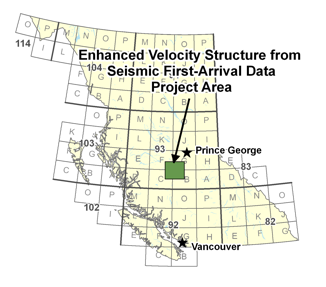
Our second step involves application of waveform tomography to the 2008 data set, which with maximum offsets to ~15 km will enable well-resolved velocity and attenuation structures to depths of 2000-3000 m. In collaboration with geologists knowledgeable of the Nechako Basin and seismologists involved in the main seismic survey, the velocity and attenuation models will be interpreted in terms of subsurface structure, distinguishing glacial deposits, sedimentary rocks and volcanics, and perhaps identifying shallow sub-basins within the Nechako Basin. The enhanced velocity structure also may be used in a second-stage of processing of the main reflection data to provide improved images where warranted.